Architectural Drawing and 3D Modeling for Planning, Design and Communication
Architectural Drawing and 3D Modeling for Planning, Design and Communication
Training Modules and Facilitator The training program is organized into three progressive phases comprising 15 thematic modules totaling 45 hours. Phase 01: Basic 2D Graphics using AutoCAD (5 Sessions, 15 Hours) Date Module 10 April Pre-assessment Dr. Md. Salauddin 15, 16 April Introduction to AutoCAD: Interface Navigation, Workspace Configuration, and Foundational Drawing Commands KZ Architects Ar. Omar Faruq 17 April B1, B2 Drawing and Editing Tools with Coordinate Systems, Drawing Scales, and Planning-Specific Drafting Standards KZ Architects Ar. Omar Faruq 18 April B1, B2 Layers, Line Types, Colors, Text, Dimensions, Hatching, and Professional Drawing Organization KZ Architects Ar. Khan Zahid 19, 20 April Applied Site Plan and Land Use Drawing: Raster Process Integration and Planning Scenario Practice KZ Architects Ar. Khan Zahid 22, 23 April Layout Preparation, Printing Setup, Viewport Configuration, and File Management Md Toukir Hossain Phase 02: Advanced 3D Modelling using SketchUp (18 Hours | Days 6–11) Date Module 24 April B1, B2 Introduction to SketchUp: Interface, Navigation Tools, and Foundational 3D Drawing and Geometry Rifat Bin Firoz 25 April B1, B2 Importing AutoCAD Files and Establishing 3D Urban Model Bases from 2D Plans Rifat Bin Firoz 26, 27 April Advanced Modeling Techniques, Groups, Components, and the 3D Warehouse Rifat Bin Firoz Mid Term 29, 30 April Site Modeling, Terrain Development using Sandbox Tools, Shadow Simulation, and Scene Configuration Rifat Bin Firoz 2 May B1, B2 Integrated 3D Modeling Exercise, Individual Instructor Support, and Technical Q&A Session Rifat Bin Firoz 3, 4 May Special Features Design Exercise: Object Design, Ergonomic Criteria, and Landscape Element Modeling Rifat Bin Firoz Phase 03: Rendering and Animation using Lumion and D5 Render (12 Hours | Days 12–15) Module 6, 7 May Introduction to Lumion: Model Import, Interface Navigation, Material Assignment, and Scene Population Md Toukir Hossain 8 May B1, B2 Lumion Lighting, Atmospheric Effects, Camera Composition Principles, and Rendering Output Production Md Toukir Hossain 9 May B1, B2 Introduction to D5 Render and Animation Clip Production using Lumion Md Toukir Hossain 10, 11 May Final Project Presentation, Panel Review, and Comprehensive Course Evaluation Md Toukir Hossain 13 May Final Evaluation Session Details TOPIC SESSION 01: Introduction to AutoCAD, Interface Navigation & Basic Drawing (3 Hours) • Introduction with the final Project 3D rendered view, demonstrate about the necessity of Visualization work. What will produce the participants in the 1st phase will also be shown in example. • This introduces the philosophy of CAD drafting and its significance in contemporary planning practice. Students will explore the AutoCAD workspace, including the ribbon, command line, drawing area, and status bar. Core setup procedures, such as unit configuration and workspace customization will be demonstrated. • Navigation tools including Zoom, Pan, and Object Snap will be practiced to build familiarity with the working environment. Students will draw their first objects using the LINE and ERASE commands to develop initial comfort with the interface. • The session will further cover the essential drawing toolkit. SESSION 02: Basic Drawing and Editing Tools with Scales, Drawing Standards, and Planning-Specific Applications (3 Hours) • Emphasis will be placed on precision input through coordinate systems (absolute, relative, and polar coordinates). By the conclusion of this session, students will be capable of constructing accurate geometric compositions with confidence. • The concept of drawing scale will be introduced, with particular focus on the relationship between real-world dimensions and their graphical representation on paper or screen. Commonly used scales in urban planning practice like decimal and architectural scale will be discussed through practical examples relevant to site plans, land use maps, and structure plans. • Standard drafting conventions, including line weights, line types (continuous, dashed, and center), and graphic symbols, will be introduced to familiarize students with professional drawing communication standards. • A 2D standard plan will be shown in the end of this session SESSION 03: Layers, Line Types, Colors, Text, Dimensions, Hatching, and Drawing Organization (3 Hours) • In this session organized layer fill will be shown to the students. and demonstrate them about the significance of layers in drawing • Professional CAD drawings rely heavily on a well-organized layer structure. This session teaches students how to create, manage, and utilize layers for organizing distinct drawing elements: such as roads, buildings, vegetation, water bodies, and plot boundaries within a planning context. • Layer properties including color coding, line type assignment, line weight, and visibility control will be addressed in detail. Students will also learn to use the PROPERTIES palette and MATCHPROP command to maintain consistency throughout a drawing. • The session further focuses on professional drawing annotation. SESSION 04: Site Plan, Raster and Land Use Drawing Practice (3 Hours) • This is a hands-on applied session in which the raster process will be introduced, and students will draft a simplified site plan or land use map using all tools covered in preceding sessions. The exercise will simulate a realistic planning scenario (such as a neighborhood block or a small urban area) incorporating road networks, plot boundaries, building footprints, open spaces, and land use hatching. • Layer organization, annotation accuracy, and scale compliance will be evaluated throughout the exercise. This session is designed to build students' confidence in applying individual skills cohesively within a practical drafting context. A short home assignment will be issued for the finalization of this phase. SESSION 05: Layout, Printing Setup, and File Management (3 Hours) • This session will open with a Q&A review based on the home assignment, clarifying the complete drawing production process and addressing any outstanding queries from students. • The session will then guide students through the transition from model space drafting to paper space presentation. Topics covered include the creation of layouts with title blocks, configuration of viewports, assignment of correct plot scales, and setup of page settings for printing or PDF export. File management best practices will also be addressed. • By the end of this session, students will be fully equipped to produce a print-ready drawing package. SESSION 06: Introduction to SketchUp Interface and Basic 3D Tools (3 Hours) • A basic Raw 3D file will be shown in this session. And demonstrate the students about the present national issue in planning and how they can design conceptual space with 3D tool. • Students will be introduced to the SketchUp workspace, including the toolbar, axis system, and primary navigation tools (Orbit, Pan, and Zoom). Core drawing tools such as LINE, RECTANGLE, CIRCLE, and ARC, alongside fundamental modeling tools including PUSH/PULL, MOVE, ROTATE, and SCALE, will be demonstrated. • The concept of faces and edges as the foundational building blocks of SketchUp geometry will be thoroughly explained. Students will create simple 3D masses (boxes, cylinders, and custom shapes) to understand how two-dimensional geometry is extruded into three-dimensional form. SESSION 07: Importing AutoCAD Files and Starting 3D Models (3 Hours) • For the constructive workflow students group will be formed and they will assign a survey work for design demonstration. • This session establishes the critical workflow connection between AutoCAD and SketchUp. Students will learn how to import DWG files into SketchUp and use a 2D floor plan or site plan as a base for three-dimensional modeling. • Topics covered include cleaning up imported geometry, tracing over CAD lines, and extruding building volumes from plan footprints. The session also addresses the use of GROUPS and COMPONENTS to organize models, preserve geometric clarity, and improve overall software performance. • Students will begin constructing a basic 3D urban block model derived directly from their previous AutoCAD site plan exercise. SESSION 08: Advanced Modeling, Components, and the 3D Warehouse (3 Hours) • This session expands students' modeling capabilities through the introduction of complex 3D forms and the application of Move, Rotate, and Scale tools in three-dimensional space. Advanced tools such as FOLLOW ME used for creating complex extrusions along a defined path and INTERSECT FACES used for producing intricate geometric interactions will be demonstrated. • Students will also learn to utilize the 3D Warehouse to access and download pre-made components including trees, street furniture, vehicles, and people, integrating them into their urban models to add realism and contextual depth. Material application using SketchUp's native material browser will be introduced, enabling students to assign colors and textures to model surfaces. SESSION 09: Site Modeling, Terrain, and Scene Setup (3 Hours) • Some different landscape will be introduced in the beginning of this session and demonstrate the students how they can generate this works. • This session focuses on placing the 3D model within a realistic site environment. Students will learn to model terrain and sloped ground using the SANDBOX tools. • Shadow settings will be configured to simulate actual sunlight conditions based on geographic location and time of day an analytical method with direct relevance to urban planning practice. Scene tabs will be introduced as a tool for capturing multiple camera views and designated viewpoints within a single project file. SESSION 10: Exercise and Q&A Session (3 Hours) • In this session, students will develop their previously completed 2D site plans into fully realized 3D models. Any technical challenges encountered during the process will be addressed individually through direct instructor support. • Upon completion, the 3D models will be formally assessed by the instructors. The evaluation criteria will be based on the volume of work produced and the level of precision demonstrated. SESSION 11: Special Features Design Exercise (3 Hours) • Introduce Ergonomics and comfortable design philosophy in urban space with some example. • This session introduces object design within a planning context. Fundamental ergonomic principles and human-centered design criteria will be presented to provide a conceptual foundation. • To develop hands-on creative experience, each student will select and declare a specific landscape object or element of their choice for independent design. A detailed 3D model of the selected object will then be developed, with the model scale determined by the course instructors. • By the end of this session, students will have a complete, well-organized 3D urban model prepared for export to rendering software. SESSION 12: Introduction to Model Import and the Lumion Interface (3 Hours) • This session will start with a animation clip and some 3D rendered image. What will be demonstrate in the final phase. • Students will be introduced to the Lumion interface, covering the build mode, landscape tools, and the library of objects, materials, and visual effects. Students will import their SketchUp models into Lumion, replacing placeholder materials with high-quality alternatives (including concrete, glass, brick, grass, asphalt, and water) to begin populating the scene with trees, people, vehicles, and street furniture from Lumion's extensive object library. • The landscape terrain and sky environment will be configured to establish a convincing and contextually appropriate scene setting. SESSION 13: Lumion Lighting, Effects, and Rendering Output (3 Hours) • This session focuses on achieving photorealistic output through Lumion's rendering pipeline. Students will configure sun position, time of day, weather conditions, and atmospheric effects such as fog and cloud cover. • Lumion's effects system (Hyperlight, bloom, lens flare, depth of field, color correction, and ambient occlusion) will be explored to enhance overall visual quality. Principles of camera composition, such as framing, perspective, and focal length, will also be introduced. SESSION 14: Animation clip production using Lumion & Short Introduction to D5 Render & Ai based tool (3 Hours) • In the initial phase of this session, students will begin by exploring animation production using Lumion. They will focus on creating animations by configuring camera paths, defining keyframes, and utilizing Lumion’s animation tools to produce dynamic visual walkthroughs. • The session will then proceed with the installation of the D5 SketchUp plugin, where students will synchronize their models into D5 Render and familiarize themselves with the D5 interface. The session will cover material replacement, lighting configuration using the HDRI sky system and artificial light sources, as well as scene composition. • Students will also be introduced to AI-based tools, such as Nana Banana, which leverage machine learning to automate and optimize tasks like material adjustments, lighting enhancements, and scene refinement. These tools will help students improve rendering efficiency and quality. • The session will conclude with a comparative discussion, examining the key differences in workflow, material library depth, rendering speed, and output quality between Lumion and D5 Render, and exploring how AI-based tools like Nana Banana can streamline rendering and animation production. SESSION 15: Final Project Presentation and Course Review (3 Hours) • The final session is dedicated to student presentations. Each student will present their completed project (3D visualization/ rendered images, a walkthrough animation) on a structured presentation. • Constructive feedback will be provided on technical execution, visual quality, and professional presentation standards. The session will conclude with a comprehensive course review, a discussion on the career applications of these tools within the planning profession, and guidance on recommended resources for continued self-directed learning beyond the course. Training Methodology Foundational Approach The training adopts a participatory, learner-centered, and practice-oriented pedagogical philosophy. All sessions are structured to bridge theoretical and conceptual knowledge with real-world planning applications relevant to urban and rural contexts in Bangladesh. The methodology emphasizes progressive skill-building, peer collaboration, and the sequential application of digital tools by advancing from two-dimensional technical drafting through to photorealistic three-dimensional visualization. Each phase builds directly upon the preceding one (Prerequisite session), ensuring that participants develop a cohesive and professionally applicable digital workflow. Delivery Methods Lectures and Conceptual Sessions Structured presentations by trainers on CAD drafting principles, 3D modeling theory, rendering concepts, and spatial visualization standards for planning practice. Planning-relevant case studies from Bangladesh and South Asia will be used to contextualize each phase and module. Q&A discussions and reflective debriefing segments will be embedded at the close of each session to consolidate participant understanding. Live Software Demonstrations Step-by-step guided walkthroughs of AutoCAD, SketchUp, Lumion, and D5 Render using real planning datasets and urban design scenarios. All demonstrations will be screen-shared and projected for the entire class. Basic command list for each software will be distributed to participants for self-paced review between sessions. Hands-On Exercises and Project-Based Practice Participants will work directly within software environments during the lab sessions. Individual and paired exercises are designed to reinforce practical competencies following each module, ensuring skill consolidation at every stage. Assessment Methods Attendance 10% Class attendance Quiz and Assignment 20% Short quiz, MCQ, Single-task assignment (2 in-session assessment) Mid Term Exam 20% Written and Lab-based exam Individual Project 25% Individual Problem-Solving Project (2 projects) Final Assessment 25% Written and Lab-based exam Group Assignments and Planning-Scenario-Based Learning Team-based assignments requiring participants to collaboratively develop and present a small-scale urban visualization project. Case scenarios drawn from planning contexts in Bangladesh (such as neighborhood redevelopment, urban corridor design, open space planning, and residential site layout) will be used as the basis for applied group exercises. Presentations at the end of each phase will consolidate cumulative learning, with structured peer-review and instructor feedback sessions integrated throughout. Integrated Final Project Workshop A capstone workshop conducted in Day 15 in which participants consolidate their AutoCAD, SketchUp, Lumion, and D5 Render outputs into a complete and professionally structured 3D visualization package. Participants will present their final project before a panel of faculty and planning professionals in a format simulating a professional design review. Training Materials Material Format Language Module Presentations PowerPoint / PDF English Training Manual Printed + Digital (PDF) English AutoCAD Practice Drawing Files DWG English SketchUp Base Model Files SKP English Lumion Scene Reference Files LS/ LSS English D5 Render Project Files D5A English Case Study Materials PDF Booklets English Evaluation Tools (Pre / Mid / Final) Paper + Digital English Final Project Submission Template PPTX English Assessment and Evaluation Method Timing Tool Pre-Training Knowledge Assessment Before Phase 1 (Day 1) Paper / Digital Quiz (20 Questions) Mid-Term Evaluation End of Session 7 (Post-AutoCAD and Foundational SketchUp Modules) Practical + Mini Drawing Assignment Post-Training Assessment End of Session 15 (Day 15) Software Practical + Project Presentation Participant Feedback Forms One in every two weeks QR-Code Digital Survey / Google Forms Final Project Review Session 14–15 Panel Evaluation of 3D Visualization Package Pre-Assessment Framework A pre-training assessment will be administered on Day 1 to determine participants' baseline knowledge and calibrate the training depth and pace accordingly. Section Area Number of Questions CAD and Technical Drawing Fundamentals Understanding of scale, line types, and drafting conventions 04 AutoCAD Software Familiarity Basic interface and command-line awareness 04 3D Modeling Concepts Understanding of 3D geometry, extrusion, and spatial form 03 Rendering and Visualization Awareness of rendering software types and visual output 03 Planning Representation Standards Knowledge of spatial documentation and planning graphics 03 General Digital Design Literacy Familiarity with design software environments and file management 03 TOTAL 20 Questions Multiple choice | Scenario-based questions | Visual and spatial interpretation questions Mid-Term Evaluation (After Session 7, Post-AutoCAD and Foundational SketchUp Modules): Total Marks: 20 Component Weight AutoCAD Practical Assessment (Site Plan Drawing Task) 20% SketchUp Mini Modeling Assignment 40% TOTAL (Mid-Term Weight) 60% Final Evaluation (After Session 15) Total Marks: 25 Component Weight Final Written Test 20% (****) AutoCAD Practical Assessment 20% SketchUp Practical Assessment 20% Lumion / D5 Render Visualization Output 20% Final Project Presentation 20% TOTAL 100% Final Project (Total Marks: 25) Participants will complete a comprehensive 3D visualization project based on a provided urban planning scenario. Participants must: Produce a complete AutoCAD 2D site plan with accurate layer organization, dimension annotation, hatching, and a print-ready layout Develop a detailed SketchUp 3D urban model built from the AutoCAD base, including building volumes, terrain, and contextual scene elements Apply materials, configure lighting, and produce photorealistic rendered still images and a short walkthrough animation using Lumion Compile all outputs into a structured visualization portfolio and present findings before a panel of faculty evaluators Key Performance Indicators (KPIs) ≥80% of participants achieve a passing score in the final evaluation ≥90% of participants successfully complete the final integrated visualization project ≥85% of participants demonstrate functional competency across AutoCAD, SketchUp, and Lumion/D5 Render Measurable improvement recorded between pre-training and post-training assessment scores across all phases Participant satisfaction score of ≥4.0/5.0 based on end-of-training feedback forms Certification Criteria Participant will receive certification if he/she: Attend at least 70% of all training sessions Score a minimum of 60% in the final evaluation Successfully complete and present the final analytical project Expected Outcomes Outcome Indicator Improved proficiency in 2D CAD drafting for professional planning documentation AutoCAD practical assessment scores; site plan drawing output quality Enhanced ability to construct detailed 3D urban models using SketchUp SketchUp practical assessment results; model accuracy, completeness, and organizational quality Competency in photorealistic scene rendering and visualization using Lumion or D5 Rendered image quality; animation output coherence and visual communication effectiveness Integration of 2D drawings, 3D models, and rendered outputs into a professional visualization package Final project portfolio quality and panel evaluation scores Contribution to EDGE Project goals Certification rates; alignment of visualization outputs with BCC objectives and professional planning practice standards
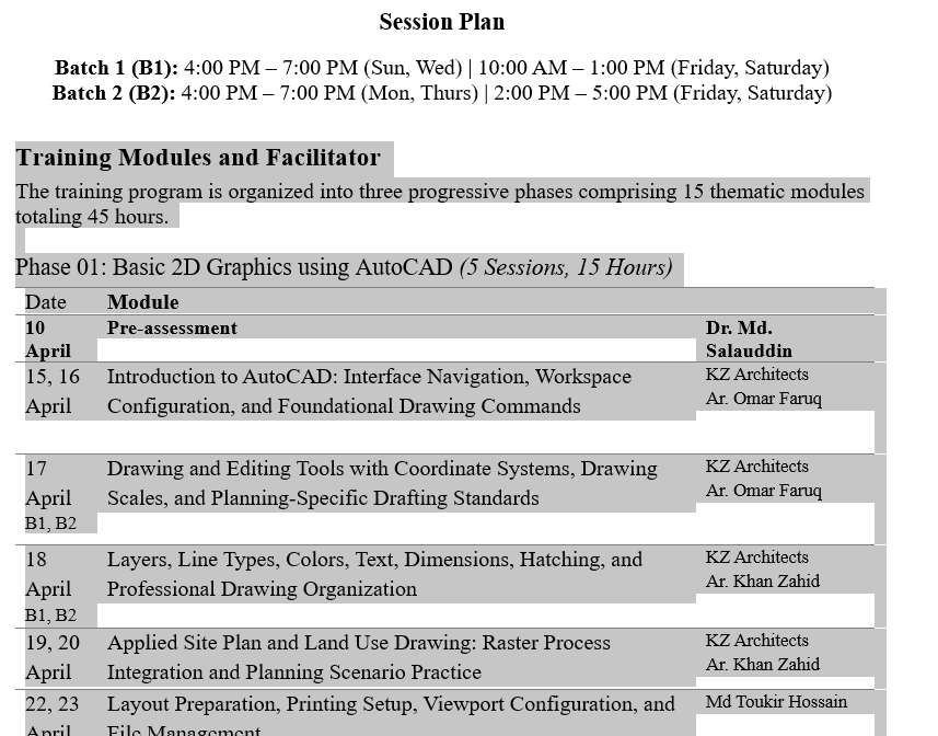
Training Modules and Facilitator
The training program is organized into three progressive phases comprising 15 thematic modules totaling 45 hours.
Phase 01: Basic 2D Graphics using AutoCAD (5 Sessions, 15 Hours)
|
Date |
Module |
|
|
10 April |
Pre-assessment |
Dr. Md. Salauddin |
|
15, 16 April |
Introduction to AutoCAD: Interface Navigation, Workspace Configuration, and Foundational Drawing Commands |
KZ Architects Ar. Omar Faruq |
|
17 April B1, B2 |
Drawing and Editing Tools with Coordinate Systems, Drawing Scales, and Planning-Specific Drafting Standards |
KZ Architects Ar. Omar Faruq |
|
18 April B1, B2 |
Layers, Line Types, Colors, Text, Dimensions, Hatching, and Professional Drawing Organization |
KZ Architects Ar. Khan Zahid |
|
19, 20 April |
Applied Site Plan and Land Use Drawing: Raster Process Integration and Planning Scenario Practice |
KZ Architects Ar. Khan Zahid |
|
22, 23 April |
Layout Preparation, Printing Setup, Viewport Configuration, and File Management |
Md Toukir Hossain |
Phase 02: Advanced 3D Modelling using SketchUp (18 Hours | Days 6–11)
|
Date |
Module |
|
|
24 April B1, B2 |
Introduction to SketchUp: Interface, Navigation Tools, and Foundational 3D Drawing and Geometry |
Rifat Bin Firoz |
|
25 April B1, B2 |
Importing AutoCAD Files and Establishing 3D Urban Model Bases from 2D Plans |
Rifat Bin Firoz |
|
26, 27 April |
Advanced Modeling Techniques, Groups, Components, and the 3D Warehouse |
Rifat Bin Firoz |
|
|
Mid Term |
|
|
29, 30 April |
Site Modeling, Terrain Development using Sandbox Tools, Shadow Simulation, and Scene Configuration |
Rifat Bin Firoz |
|
2 May B1, B2 |
Integrated 3D Modeling Exercise, Individual Instructor Support, and Technical Q&A Session |
Rifat Bin Firoz |
|
3, 4 May |
Special Features Design Exercise: Object Design, Ergonomic Criteria, and Landscape Element Modeling |
Rifat Bin Firoz |
Phase 03: Rendering and Animation using Lumion and D5 Render (12 Hours | Days 12–15)
|
|
Module |
|
|
6, 7 May |
Introduction to Lumion: Model Import, Interface Navigation, Material Assignment, and Scene Population |
Md Toukir Hossain |
|
8 May B1, B2 |
Lumion Lighting, Atmospheric Effects, Camera Composition Principles, and Rendering Output Production |
Md Toukir Hossain |
|
9 May B1, B2 |
Introduction to D5 Render and Animation Clip Production using Lumion |
Md Toukir Hossain |
|
10, 11 May |
Final Project Presentation, Panel Review, and Comprehensive Course Evaluation |
Md Toukir Hossain |
|
13 May |
Final Evaluation |
|
Session Details
|
SESSION 01: Introduction to AutoCAD, Interface Navigation & Basic Drawing (3 Hours) |
|
· Introduction with the final Project 3D rendered view, demonstrate about the necessity of Visualization work. What will produce the participants in the 1st phase will also be shown in example. · This introduces the philosophy of CAD drafting and its significance in contemporary planning practice. Students will explore the AutoCAD workspace, including the ribbon, command line, drawing area, and status bar. Core setup procedures, such as unit configuration and workspace customization will be demonstrated. · Navigation tools including Zoom, Pan, and Object Snap will be practiced to build familiarity with the working environment. Students will draw their first objects using the LINE and ERASE commands to develop initial comfort with the interface. · The session will further cover the essential drawing toolkit.
|
|
SESSION 02: Basic Drawing and Editing Tools with Scales, Drawing Standards, and Planning-Specific Applications (3 Hours) |
|
· Emphasis will be placed on precision input through coordinate systems (absolute, relative, and polar coordinates). By the conclusion of this session, students will be capable of constructing accurate geometric compositions with confidence. · The concept of drawing scale will be introduced, with particular focus on the relationship between real-world dimensions and their graphical representation on paper or screen. Commonly used scales in urban planning practice like decimal and architectural scale will be discussed through practical examples relevant to site plans, land use maps, and structure plans. · Standard drafting conventions, including line weights, line types (continuous, dashed, and center), and graphic symbols, will be introduced to familiarize students with professional drawing communication standards. · A 2D standard plan will be shown in the end of this session
|
|
SESSION 03: Layers, Line Types, Colors, Text, Dimensions, Hatching, and Drawing Organization (3 Hours) |
|
· In this session organized layer fill will be shown to the students. and demonstrate them about the significance of layers in drawing · Professional CAD drawings rely heavily on a well-organized layer structure. This session teaches students how to create, manage, and utilize layers for organizing distinct drawing elements: such as roads, buildings, vegetation, water bodies, and plot boundaries within a planning context. · Layer properties including color coding, line type assignment, line weight, and visibility control will be addressed in detail. Students will also learn to use the PROPERTIES palette and MATCHPROP command to maintain consistency throughout a drawing. · The session further focuses on professional drawing annotation. |
|
SESSION 04:
|